Ontario

Province Code
ON
City/Municipality
Windsor
Memorial Number
35020-025
Type
Address
1812, Promenade Riverside Est
Location
Sur le terrain de la société Hiram Walker (lieu approximatif du débarquement)
in Canada
Oui
GPS Coordinates
42.32597, -83.01216
Inscription

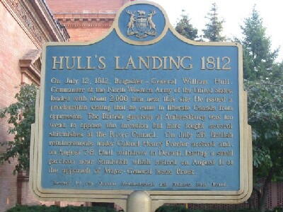
HULL'S LANDING 1812
On July 12, 1812, Brigadier-General William Hull,
Commander of the North Western Army of the United States,
landed with about 2,000 men near this site. He issued a
proclamation stating that he came to liberate Canada from
oppression. The British garrison at Amherstburg was too
weak to oppose the invasion but later fought several
skirmishes at the River Canard. On July 26, British
reinforcements under Colonel Henry Proctor arrived and,
on August 7-8, Hull withdrew to Detroit, leaving a small
garrison near Sandwich which retired on August 11 at
the approach of Major-General Isaac Brock.

Erected by the Ontario Archeaological and Historic Sites Board.

Image
Crédit photo
(www.ontarioplaques.com)
Légende
front
Province
!4v1622657396514!6m8!1m7!1sDRHfBB-5M7Jebu8Bh2DcZA!2m2!1d42.32590887930846!2d-83.01223558247327!3f32.44964197412685!4f-3.1923951963532176!5f3.1859676515772235"
Body Content

Cette plaque a été posée en 1958.

City
Windsor
Country
Type Description
Provincial Military Plaque
Memorial CF Legacy ID
4545
City/Municipality
LaSalle
Memorial Number
35020-024
Type
Address
ligne Adams & rue Laurier
Location
Parc commémoratif au bout de la rue Laurier, près du coin de la ligne Adams & de la rue Laurier
in Canada
Oui
GPS Coordinates
42.2372354, -83.1054318
Inscription

FIGHTING ISLAND 1838

On the night of February 23-24, 1838, a small force of
"Patriots" was ferried from Detroit to Fighting Island,
opposite here, whence an attack against Sandwich was
planned. They were joined the following day by "General"
Donald McLeod, a British army veteran and former resident
of Prescott who brought several hundred supporters from
Cleveland. Advised by the American general, Hugh Brady,
of the proposed attack, British regulars and Canadian
militia in the area moved against the insurgents on February
25th. After a sharp skirmish, the poorly armed "Patriots"
retreated to the Michigan shore where they were dispersed
by American troops.

Erected by the Ontario Archaeological and Historic Sites Board

Province
!4v1626710167996!6m8!1m7!1smLq1E_nLzZJVhgfUFWEwMQ!2m2!1d42.23723541835287!2d-83.10543184055658!3f302.7715846615731!4f-0.41764501304982105!5f3.325193203789971"
Body Content

Cette plaque a été posée en 1959.

City
LaSalle
Country
Type Description
Provincial Military Plaque
Memorial CF Legacy ID
4575
City/Municipality
Amherstburg
Memorial Number
35020-023
Type
Address
chemin Front Nord
Location
Pont de la rivière Canard, près de l'allée Sari
in Canada
Oui
GPS Coordinates
42.1693513, -83.0979616
Inscription

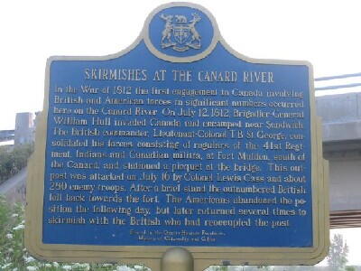
SKIRMISHES AT THE CANARD RIVER

In the War of 1812 the first engagement in Canada involving
British and American forces in significant numbers occurred
here on the Canard River. On July 12, 1812, Brigadier-General
William Hull invaded Canada and encamped near Sandwich.
The British commander Lieutenant-Colonel T.B. St. George, con-
solidated his forces, consisting of regulars of the 41st Regi-
ment, Indians and Canadian militia, at Fort Malden, south of
the Canard, and stationed a picquet at the bridge. This out-
post was attacked on July 16 by Colonel Lewis Cass and about
280 enemy troops. After a brief stand the outnumbered British
fell back towards the fort. The Americans abandoned the po-
sition the following day, but later returned several times to
skirmish with the British who had reoccupied the post.

Erected by the Ontario Heritage Foundation
Minstry of Citizenship and Culture

ESCARMOUCHES PRÈS DE LA RIVIÈRE CANARD

Pendant la guerre de 1812, la première confrontation impor-
tante au Canada entre les forces britanniques et américaines
a lieu ici, près de la rivière Canard. Le 12 juillet 1812,
William Hull, brigadier général, envahit le Canada et campe
près de Sandwich. T.B. St. George, lieutenant-colonel britan-
nique, consolide ses forces comprenant des soldats du 41e
régiment, des Indiens et la milice canadienne, au Fort Malden, 
au sud de la rivière et garde le pont. Le 16 juillet, le colonel
Lewis Cass, accompagné d'environ 280 troupes, attaque cet
avant-poste. Après une brève opposition, les Britanniques,
surpassés en nombre, se retirent vers le fort. Les Américains
abandonnent leur position le lendemain mais y reviennent
plusieurs fois pour attaquer les Britanniques.

Érigé par la Fondation du patrimoine ontarien
Ministère des Affaires civiques et culturelles

Image
Crédit photo
Ontario's Historical Plaques
Légende
Skirmishes at the Canard River Plaque
Province
!4v1632920880371!6m8!1m7!1sfejWID8OhXFE8aVJ_jsBGw!2m2!1d42.1693512988155!2d-83.09796157542684!3f184.09448360096613!4f-10.032332834764205!5f3.325193203789971"
Body Content

La plaque commémorative des escarmouches sur la rivière Canard a été posée en 1975.

City
Amherstburg
Country
Type Description
Plaque
Memorial CF Legacy ID
4582
City/Municipality
Amherstburg
Memorial Number
35020-022
Type
Address
779, rue Front Sud
Location
Dans la cour de la maison au 779 chemin Front Sud
in Canada
Oui
GPS Coordinates
42.0850272, -83.1130564
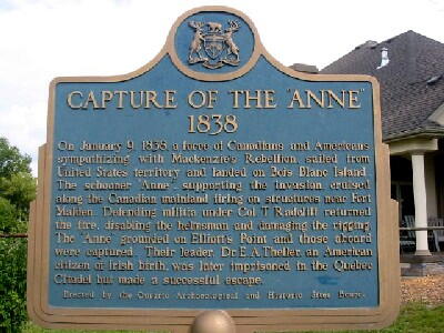
Inscription

CAPTURE OF THE "ANNE"
1838

On January 9, 1838, a force of Canadians and Americans
sympathizing with Mackenzie's Rebellion, sailed from
United States territory and landed on Bois Blanc Island.
The schooner "Anne", supporting the invasion, cruised
along the Canadian mainland firing on structures near Fort
Malden. Defending militia under Col. T. Radcliff returned
the fire, disabling the helmsman and damaging the rigging.
The "Anne" grounded on Elliott's Point and those aboard
were captured. Their leader, Dr. E.A. Theller, an Amercian
citizen of Irish birth, was later imprisoned in the Quebec
Citadel but made a successful escape.

Erected by the Ontario Archaeological and Historic Sites Board.

Image
Crédit photo
(www.ontarioplaques.com)
Légende
front
Province
!4v1623849942781!6m8!1m7!1sFlAKNjTegoRVb7Qsmb3vKw!2m2!1d42.08502718646538!2d-83.11305644155534!3f131.72192872900476!4f-6.529723645776997!5f3.325193203789971"
Body Content

Cette plaque a été posée en 1959.

City
Amherstburg
Country
Type Description
Provincial Military Plaque
Memorial CF Legacy ID
4581
City/Municipality
Bois Blanc (Bob-Lo)
Memorial Number
35020-021
Type
Address
boulevard Bob Lo Island
Location
Près du blockhaus sur l'île Bois Bland, près de la zone de conservation White Sands
in Canada
Oui
GPS Coordinates
42.08756, -83.12001
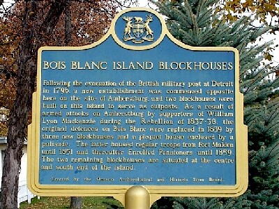
Inscription

BOIS BLANC ISLAND BLOCKHOUSES

Following the evacuation of the British military post at Detroit
in 1796, a new establishment commenced opposite
here on the site of Amherstburg, and two blockhouses were
built on this island to serve as outposts. As a result of
armed armed attacks on Amherstburg by supporters of William
Lyon Mackenzie during the Rebellion of 1837-38, the
original defences on Bois Blanc were replaced in 1839 by
three new blockhouses and a picquet house enclosed by a
palisade. The latter was occupied by regular troops from Fort Malden
until 1851 and thereafter housed Enrolled Pensioners until 1859.
The two remaining blockhouses are situated at the centre
and south end of the island.

Erected by the Ontario Archaeological and Historic Sites Board.

Image
Crédit photo
Bill Jarvis (www.ontarioplaques.com)
Légende
front
Province
Body Content

Cette plaque a été posée en 1960.

City
Bois Blanc (Bob-Lo)
Country
Type Description
Provincial Military Plaque
Memorial CF Legacy ID
4579
City/Municipality
Windsor
Memorial Number
35020-020
Type
Address
promenade Riverside
in Canada
Oui
GPS Coordinates
42.313356, -83.0630406
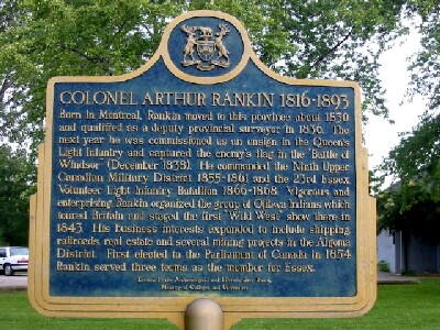
Inscription

COLONEL ARTHUR RANKIN 1816-1893

Born in Montreal, Rankin moved to this province about 1830
and qualified as a deputy provincial surveyor in 1836. The
next year he was commissioned as an ensign in the Queen's
Light Infantry and captured the enemy's flag in the "Battle of
Windsor" (December 1838). He commanded the Ninth Upper
Canadian Military District 1855-1861 and the 23rd Essex
Volunteer Light Infantry Battalion 1866-1868. Vigorous and
enterprising, Rankin organized the group of Ojibwa Indians which
toured Britain and staged the first "Wild West" show there in
1843. His business interests expanded to include shipping,
railroads, real estate and several mining projects in the Algoma
District. First elected to the Parliament of Canada in 1854
Rankin served three terms as the member for Essex.

Erected by the Archaeological and Historic Sites Board
Ministry of Colleges and Universities

Image
Crédit photo
Bill Jarvis (www.ontarioplaques.com)
Légende
front
Province
Body Content

Cette plaque est dédiée au colonel Arthur Rankin.

City
Windsor
Country
Type Description
Provincial Military Plaque
Memorial CF Legacy ID
4561
City/Municipality
Amherstburg
Memorial Number
35020-019
Type
Address
779, chemin Front Sud
Location
Dans la cour de la maison au 779 chemin Front Sud
in Canada
Oui
GPS Coordinates
42.084855, -83.1132313
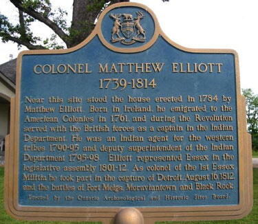
Inscription

COLONEL MATTHEW ELLIOTT
1739-1814

Near this site stood the house erected in 1784 by
Matthew Elliott. Born in Ireland, he emigrated to the
American Colonies in 1761, and during the Revolution
served with the British forces as a captain in the Indian
Department. He was an Indian agent for the western
tribes 1790-95 and deputy superintendent of the Indian
Department 1795-98. Elliott represented Essex in the
legislative assembly 1801-12. As colonel of the 1st Essex
Militia he took part in the capture of Detroit, August 16, 1812,
and the battles of Fort Meigs, Moraviantown and Black Rock.

Erected by the Ontario Archaeological and Historic Sites Board.

Image
Crédit photo
(www.ontarioplaques.com)
Légende
plaque
Province
!4v1623849513302!6m8!1m7!1svRUSmbN5AbbpHrseBLrCmw!2m2!1d42.08485500562814!2d-83.1132312689594!3f82.02770726544982!4f-3.6449813477585593!5f3.325193203789971"
Body Content

Cette plaque portant le titre "COLONEL MATTHEW ELLIOTT 1739-1814",est dédiée au colonel Matthew Elliott.

City
Amherstburg
Country
Type Description
Provincial Military Plaque
Memorial CF Legacy ID
4609
City/Municipality
Amherstburg
Memorial Number
35020-018
Type
Address
chemin Holiday Beach
Location
Aire de conservation de la plage Holiday, près de la rive du lac Érie
in Canada
Oui
GPS Coordinates
42.0323234, -83.0412855
Inscription

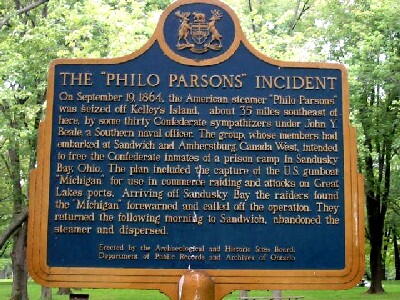
THE "PHILO PARSONS" INCIDENT

On September 19, 1864, the American steamer "Philo Parsons"
was seized off Kelly's Island, about 35 miles southeast of
here, by some twenty Confederate sympathizers under John Y.
Beall, a Southern naval officer. The group, whose members had
embarked at Sandwich and Amherstburg, Canada West, intended
to free the Confederate inmates of a prison camp in Sandusky
Bay, Ohio. The plan included the capture of the U.S. gunboat
"Michigan" for use in commerce raiding and attacks on Great
Lakes ports. Arriving off Sandusky Bay the raiders found
the "Michigan" forewarned and called off the operation. They
returned the following morning to Sandwich, abandoned the
steamer and dispersed.

Erected by the Archaeological and Historic Sites Board
Department of Public Records and Archives of Ontario

Image
Crédit photo
(www.ontarioplaques.com)
Légende
front
Province
!4v1638989995378!6m8!1m7!1s4nZTeK0Us5T3tNtCQTONJw!2m2!1d42.03232343055819!2d-83.04128550921077!3f216.0788260833652!4f0.5587059010946973!5f3.325193203789971"
Body Content

Cette plaque rappelant l’incident du Philo Parsons a été posée en 1968.

City
Amherstburg
Country
Type Description
Provincial Military Plaque
Memorial CF Legacy ID
4616
City/Municipality
Pelee Island
Memorial Number
35020-017
Type
Address
Chemins North Shore et Victoria
in Canada
Oui
GPS Coordinates
41.80857, -82.67637
Inscription

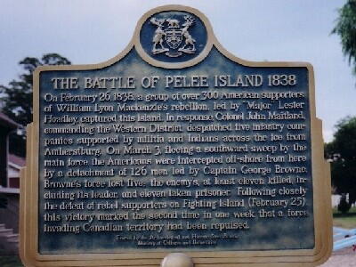
THE BATTLE OF PELEE ISLAND 1838

On February 26, 1838, a group of over 300 American supporters
of William Lyon Mackenzie's rebellion, led by "Major" Lester
Hoadley, captured this island. In response, Colonel John Maitland,
commanding the Western District, dispatched five infantry com-
panies supported by militia and Indians across the ice from
Amherstburg. On March 3, fleeing a southward sweep by the
main force, the Americans were intercepted off-shore from here
by a detachment of 126 men led by Captain George Browne.
Browne's force lost five the enemy's, at least eleven killed, in-
cluding its leader, and eleven taken prisoner. Following closely
the defeat of rebel supporters on Fighting Island (February 25),
this victory marked the second time in one week that a force
invading Canadian territory had been repulsed.

Erected by the Archaeological and Heritage Sites Board
Minisry of Colleges and University

Image
Crédit photo
Ontario's Historical Plaques
Légende
Battle of Pelee Island 1838 Plaque
Province
Body Content

La plaque commémorative de la Bataille de l’île Pelée a été posée en 1974.

City
Pelee Island
Country
Type Description
Plaque
Memorial CF Legacy ID
4560
City/Municipality
Amherstburg
Memorial Number
35020-016
Type
Address
281, rue Dalhousie
Location
Devant la Légion royale canadienne, filiale 157
in Canada
Oui
GPS Coordinates
42.101151, -83.1124003
Inscription

needs further research/recherche incomplète

Image
Crédit photo
Harry Palmer
Légende
front view
Province
!4v1622730153593!6m8!1m7!1s5CZe29H6dTTwtzrrjLl1Aw!2m2!1d42.10115097139523!2d-83.11240028310579!3f23.884768430176983!4f-0.46788015094419677!5f2.924186640401587"
Body Content

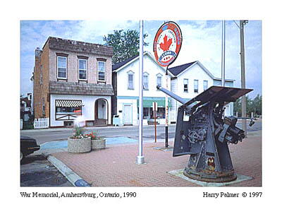
Une plaque montée sur ce canon naval no 12 indique que celui-ci a été fabriqué par le service des munitions du CP Rail à Ogden (Alberta). Ogden fait maintenant partie de Calgary, où est né le photographe, Harry Palmer. Ce dernier se rappelle que son père a travaillé comme machiniste au service des munitions du CP Rail à Ogden, où il fabriquait des canons no 12. Il croit que la machine dont se servait son père était une sorte de fraiseuse appelée « hydratel ».

City
Amherstburg
Country
Type Description
Naval gun
Memorial CF Legacy ID
4961