
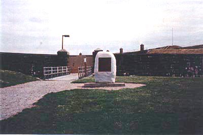
This plaque, set on a monolith by the Historic Sites and Monuments Board of Canada in 1984, commemorates Fort no. 1, at Pointe-Lévis, built between 1865 and 1871, and intended as a protection of Québec and its harbour from a possible American invasion.
Fort no. 1 Memorial Plaque
Lévis, Québec
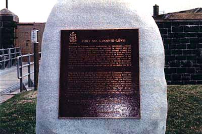
Inscription
[plaque/plaque]
FORT NO. 1, POINTE-LÉVIS
Pendant la Guerre civile américaine, le lieutenant-colonel William Jervois recommanda de fortifier la région afin de défendre Québec dans l'éventualité d'une attaque venant du Maine. Construit entre 1865 et 1871, ce fort est l'un des trois que les ingénieurs britanniques édifièrent à Pointe-Lévis. Jamais complètement armé ni occupé par une garnison, il fut pratiquement abandonné après la signature du traité de Washington en 1871 entre les États-Unis et la Grande-Bretagne. Son architecture représente la transition entre la fortification classique et l'art militaire moderne, qui se fit au milieu du XIXe siècle.
This fort is one of the three recommended by Lieutenant Colonel William Jervois during the border strains stemming from the American Civil War, and built by the Royal Engineers between 1865 and 1871. Intended to protect Québec and its harbour from a possible American invasion from Maine, it was never completely armed or garrisoned, and was virtually abandoned following the signing of the Treaty of Washington by Great Britain and the United States in 1871. The fort's design represents a transition from the principle of classical fortification to the military practices of the mid-nineteenth century.
Location
Fort no. 1 Memorial Plaque
Fort No. 1 of Pointe-Lévis
Lévis
Québec
Fort no. 1 Memorial Plaque
Fort No. 1 of Pointe-Lévis
Lévis
Québec
GPS Coordinates
Lat. 46.8241063
Long. -71.1521375
Lat. 46.8241063
Long. -71.1521375