Other

City/Municipality
Yellowknife
Memorial Number
61002-010
Type
Address
52 Street and 49th Avenue
Location
Yellowknife City Hall
in Canada
Yes
GPS Coordinates
62.4544114, -114.3751526
Inscription

VINCENT MASSEY

BRANCH No. 164

MEMORIAL

IN MEMORY OF

THE ILLUSTRIOUS DEAD

OF YELLOWKNIFE AND

IN HONOUR OF

OUR LIVING COMRADES

WHO DEFENDED OUR

COUNTRY IN ALL WARS

THIS CAIRN IS

SOLEMNLY DEDICATED

Image
Photo Credit
Gary Counsell
Caption
Yellowknife Cenotaph; photo dated 11 April 2020
1 of 2 images
Image
Photo Credit
Gary Counsell
Caption
Yellowknife Cenotaph Plaque; photo dated 11 April 2020
1 of 2 images
!4v1614867694203!6m8!1m7!1sqSOpwmPCPW5xy_Xun97Unw!2m2!1d62.45440326570806!2d-114.3753230259733!3f330.6533595010975!4f-5.13620264300495!5f3.325193203789971
Body Content

The cenotaph sits on City Hall property on a piece of land located between City Hall and the Royal Canadian Mounted Police (RCMP) G Division Headquarters and the Yellowknife RCMP Detachment (co-located at 5010 Veterans Memorial Dr (49th Ave), Yellowknife NT X1A 2R3).  Although the Yellowknife City Hall address is 52 Street, the cenotaph is located along Veterans Memorial Dr (49th Ave).

The cenotaph is four sided and made of rounded stones and cement.  The cenotaph tapers, with the base of the monument larger than the top.  The cenotaph sits on a concrete slab.  The cenotaph has a rectangular metal plaque on the front.  This can be seen by observers on the sidewalk of Veterans Memorial Dr (49th Ave).  The top of the plaque has a maple leaf, the Royal Canadian Legion crest and another maple leaf.  The maple leafs are angled to the outside by about 30 degrees.

The cenotaph is a community gathering spot on Remembrance Day, with wreaths being laid in front of the cenotaph.  Other military parades occur for commemorations such as Battle of the Atlantic and Battle of Britain.  The cenotaph is located close to the RCMP memorial at the front of their building.

The date of the cenotaph is unknown.

City
Yellowknife
Country
Type Description
Cairn
Photo Credit
Gary Counsell
Memorial CF Legacy ID
10289
City/Municipality
Geographical feature
Memorial Number
61002-007
Type
Location
35 km southeast of Sachs Harbour, on Banks Island
in Canada
Yes
GPS Coordinates
71.7837292, -124.5320894
Inscription

[on map/sur la carte]

Cape Currie

Image
Photo Credit
Map by Natural Resources Canada/ Government of Canada
War or Conflict Term
Body Content

Cape Currie is named in honour of General Sir Arthur Currie, GCMG, KCB, VD, Légion d’Honneur and Croix de Guerre (with palm) – France, Order of the Crown and Croix de Guerre – Belgium, Distinguished Service Medal – US. The cape was named on July 9, 1981 by the Government of the Northwest Territories.

General Sir Arthur William Currie was born in December 1875, in the hamlet of Napperton, near Strathroy. He moved to Victoria in 1894 and taught at public schools in the area. In 1897, he joined the 5th Regiment, Canadian Garrison Artillery (C.G.A.) and has the unique distinction of starting his military career as a pre-war militia gunner before rising through the ranks to become the first Canadian commander of the four divisions of the unified Canadian Corps of the Canadian Expeditionary Force. He was the first Canadian to attain the rank of full general. Currie’s success was based on his ability to rapidly adapt brigade tactics to the exigencies of trench warfare, using set-piece operations. Currie was not afraid to voice his disagreement with orders or to suggest strategic changes to a plan of attack, and is generally considered to be among the most capable commanders of the Western Front and one of the finest commanders in Canadian military history. A courageous and innovative officer, he is best remembered for his involvement in formulating the plan for the great victory at Vimy Ridge. Then, as the first Canadian commander of the Canadian Corps, his brilliant leadership produced the sweeping Canadian victories of the War’s Last Hundred Days. After the war, Currie was offered the position of Principal and Vice-Chancellor of McGill University. He held this post with distinction from 1920 until his death in November, 1933.

City
Geographical feature
Country
Type Description
Cape
Memorial CF Legacy ID
9135
City/Municipality
Fort Smith
Memorial Number
61002-006
Type
Address
72 Breynat Street
Location
Royal Canadian Legion, fort Smith Branch #239
in Canada
Yes
GPS Coordinates
60.00658, -111.88107
Inscription

[front plaque/plaque devant]

In Remembrance of those who have fallen -
First World War        1914-1918
Second World War    1939-1945
Korea                       1950-1953
Lest We Froget
Royal Canadian Legion
Branch No 239
Fort Smith, NWT


[back plaque/plaque arrière]

And in Remembrance of those who gave their live during
Canada`s participation in UN peacekeeping missions
Lest We Forget


Image
Photo Credit
Paul Wiedrick
Caption
front
Body Content

This cairn was erected by the Royal Canadian Legion, Fort Smith Branch, #239. Unveiled on June 25, 2011, the memorial is dedicated to the World War I, World War II and Korean War Veterans.

City
Fort Smith
Country
Type Description
Cairn
Memorial CF Legacy ID
8391
City/Municipality
Yellowknife
Memorial Number
61002-005
Type
Address
Veterans Memorial Drive, Yellowknife, NT
Location
In front of Joint Task Force North
in Canada
Yes
GPS Coordinates
62.455622, -114.3739989
Inscription

[inscription/inscription]

Veterans Monument

[left column/colonne de gauche]

This monument salutes all
Men and Women who have
Served Canada in time of
War and peace

[right column/colonne de droite]

Ce monument rend hommage
aux hommes et aux femmes qui
ont servi le Canada en temps
de guerre et de paix.

"We will Remember Them"

Erected by The Royal Canadian Legion
Unveiled November 11, 2005 by
Honorable Joseph Handley, Premier
Artist: Eli Nasogaluk

Image
Caption
front view
!4v1622549032461!6m8!1m7!1smN_z3fJKe5odU2WXLvJZxA!2m2!1d62.45562197736352!2d-114.3739989288677!3f334.3838581016872!4f-3.9571668611190205!5f3.325193203789971"
Body Content

This memorial is dedicated to all the men and women who have served Canada in time of war and peace. Erected by The Royal Canadian Legion and unveiled November 11, 2005.

This monument was damaged July 4, 2019 and is hoped to be replaced by late 2020.

City
Yellowknife
Country
Type Description
Copper statues on concrete base
Memorial CF Legacy ID
7853
City/Municipality
Mackenzie
Memorial Number
61002-004
Type
Address
in Canada
Yes
GPS Coordinates
61.6999024, -126.5683694
Inscription

[capsule scroll]

Mount Hamilton Gault, on the twentieth day of August, nineteen hundred and sixty-four, a party from Second Battalion, Princess Patricia’s Canadian Light Infantry, under command of Captain Peter Maione, scaled this mountain, erected the cairn and deposited this canister there-in.

Image
Photo Credit
Princess Patricia’s Canadian Light Infantry
Caption
Mount Hamilton Gault
1 of 3 images
Image
Photo Credit
Princess Patricia’s Canadian Light Infantry
Caption
Mount Hamilton Gault
1 of 3 images
Image
Photo Credit
Princess Patricia's Canadian Light Infantry Museum & Archives
Caption
Mount Hamilton Gault cairn
1 of 3 images
Body Content

In the early part of 1963, discussions commenced to name a mountain range or mountain after Hamilton Gault, founder of the Princess Patricia's Canadian Light Armoured (PPCLI) Regiment, in commemoration of the regiment's Jubilee. The first expedition, led by Captain F.L. Berry, consisted of five men who set out from Fort Nelson on 30 August 1963 and returned approximately on 26 September.

The second expedition, Nahanni II, set out from Fort Nelson, on 3 August 1964. Commanded by Captain P.A. Maione, the party consisted of Corporal R.R. Lewis, Lance Corporal’s J. Dalton, F.J. Huard, R.A.J. Peskett and Private W.E. Brown, with Sigfried Bucher as the cameraman. On 20 August 1964, the summit of the mountain was reached, a cairn erected, and a capsule containing a scroll was deposited. This mountain was officially named Mount Hamilton Gault.

Princess Patricia’s Canadian Light Infantry was founded for service in the First World War on August 10, 1914, and paraded for the first time at Lansdowne Park, Ottawa, Ontario, on August 23, 1914. Hamilton Gault, a prominent Montreal businessman, raised the regiment out of his own funds, making the Princess Patricia’s Canadian Light Infantry the last privately raised regiment in Canada.

City
Mackenzie
Country
Type Description
Mountain, cairn
Memorial CF Legacy ID
11509
City/Municipality
Western Arctic
Memorial Number
61002-003
Type
Address
Needs further research
Location
Sapper Range
in Canada
Yes
GPS Coordinates
0, 0
Inscription

(needs further research/recherche incomplète)

Body Content

The Canadian Military Engineers’ modern contribution to Canadian mapping is reflected in the naming of the Sapper Range of mountains in the Northwest Territory.

City
Western Arctic
Country
Type Description
Landmark (mountain range)
Memorial CF Legacy ID
6847
City/Municipality
Inuvik
Memorial Number
61002-002
Type
Address
No Name Lake Road
Location
Inuvik Cemetery
in Canada
Yes
GPS Coordinates
68.34893, -133.70462
Inscription

DEDICATED TO
OUR FALLEN COMRADES
THE MEN AND WOMEN
WHO SERVED
AND THOSE WHO
HAVE PASSED ON SINCE
LEST WE FORGET

Near the bottom, a sword design, with a wreath surrounding the handle and the word VALOR inside a rectangular box that covers part of the sword blade.

On each side of the monument, a torch and flame, with the word LEGION and the number 60.

Image
Photo Credit
Gary Counsell
Caption
surroundings
1 of 4 images
Image
Photo Credit
Gary Counsell
Caption
surroundings
1 of 4 images
Image
Photo Credit
Gary Counsell
Caption
inscription
1 of 4 images
Image
Photo Credit
Gary Counsell
Caption
front
1 of 4 images
!4v1618232436920!6m8!1m7!1sZg4kEHb-MfvijBncU54l5A!2m2!1d68.34794316571043!2d-133.6968440122322!3f278.13909700620985!4f7.106647451187683!5f1.9587109090973311
Body Content

The Royal Canadian Legion McInnes Branch Cenotaph was erected in 1998. It was designed by Fred Church out of grey granite.

City
Inuvik
Country
Type Description
Stele
Memorial CF Legacy ID
4223
City/Municipality
Hay River
Memorial Number
61002-001
Type
Address
7 Nahanni Road
Location
Royal Canadian Legion Branch No. 250
in Canada
Yes
GPS Coordinates
60.81315, -115.78566
Inscription

LEST
WE
FORGET

IN MEMORY OF
THOSE WHO HAVE
GIVEN THEIR LIVES

1914 - 1918
1939 - 1945
KOREA

Image
Photo Credit
Mark Horton
Caption
surroundings
1 of 5 images
Image
Photo Credit
Mark Horton
Caption
back
1 of 5 images
Image
Photo Credit
Jean-Sebastien Tanguay
Caption
front and right side
1 of 5 images
Image
Photo Credit
Jean-Sebastien Tanguay
Caption
front
1 of 5 images
Image
Photo Credit
Jean-Sebastien Tanguay
Caption
inscription
1 of 5 images
Body Content

Erected by Royal Canadian Legion Branch No. 250, this memorial is dedicated to the war dead of the First and Second World Wars and the Korea.

City
Hay River
Country
Type Description
Cairn - fieldstone
Memorial CF Legacy ID
3083
City/Municipality
Whitehorse
Memorial Number
60001-021
Type
Address
4128 4 Ave
in Canada
Yes
GPS Coordinates
60.70486807382, -135.03561144786
Inscription

This area was officially dedicated as a Peace Garden on October 24, 1995 by the staff and students of Christ the King Elementary School to commemorate the 50th Anniversary of the United Nations

Image
Caption
Peace Garden, Christ the King Elementary School
War or Conflict Term
Province
!4v1622557774724!6m8!1m7!1skGaT2I9gcm_ZkD3kgck5nw!2m2!1d60.72028694490658!2d-135.057210906483!3f250.20209206319868!4f-2.4778903710088684!5f2.6536916425818067"
Body Content

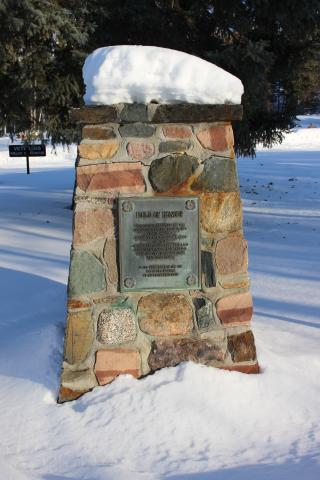
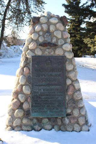
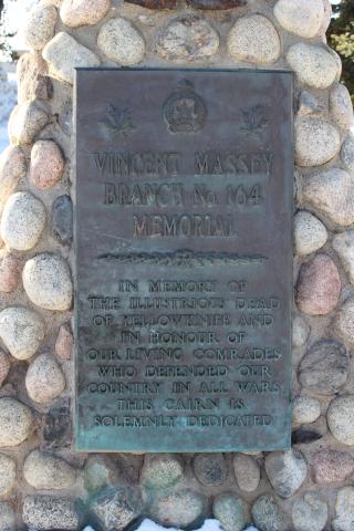
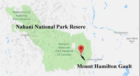
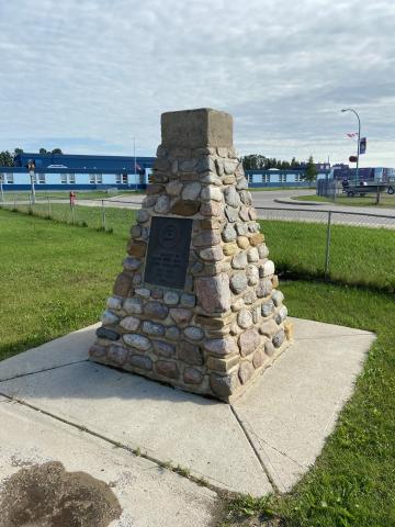
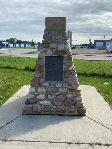
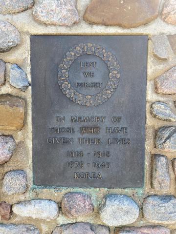
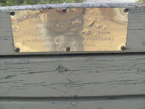
Christ the King Elementary School was designated as Whitehorse's "Peace Park" as part of Canada's 125th Birthday in 1992.

"Peace Parks Across Canada" was conceived and organized by the International Institute for Peace through Tourism (IIPT) in collaboration with "CANADA 125" and the National Capital Commission. As Canada celebrated its 125th Birthday, some 400 cities and towns across Canada dedicated a Park to Peace – with most parks dedicated at Noon local time, October 8th, as the National Peacekeeping Monument was being unveiled in Ottawa. The members of the winning design team included Cornelia H. Oberlander, landscape architect. Supporters included the Federation of Canadian Mayors and Municipalities, Canada Parks and Recreation Association, the Tourism Industry Association of Canada, Heritage Canada, World Wildlife Fund Canada, Friends of the Earth, Canadian Society of Landscape Architects, and local Rotary Clubs all across Canada. Project sponsors included VIA Rail, Greyhound Lines Canada, Ltd., CP Hotels and Resorts, Ramada International Hotels and Resorts, Four Seasons Ltd., Meridien Hotels, Concept 3 Advertising and Programmed Communications, Ltd.

Peace Parks Across Canada" has served as the foundation in launching the "IIPT Global Peace Parks Program" on the 11th hour, of the 11th day, of the 11th month, 2000

At noon on October 9th, 2007 – one day after the precise 15th Anniversary of the original dedications, and as Canada continues to be a beacon of peace, Tolerance, and Understanding in a world of increasing violence and distrust, and a nation that celebrates diversity, a nation-wide re-dedication was co-ordinated.

Each of the original Peace Parks incorporated a ‘Bosco Sacro’ (Peace Grove) of 12 trees as a symbolic link with one another, and with nature - and as a symbol of hope for the future. The 12 trees were also symbolic of Canada’s 10 Provinces and two Territories. As there are now three Territories, a 13th tree was planted as part of the "Re-dedication Ceremony."

City
Whitehorse
Country
Type Description
Peace Garden
Photo Credit
Victoria Edwards
Memorial CF Legacy ID
10141
City/Municipality
Geographical feature
Memorial Number
60001-020
Type
Address
River
Location
155 km northeast of Dawson
in Canada
Yes
GPS Coordinates
65.358867489666, -138.29678957134
Inscription

[on maps]

Engineer Creek

Image
Caption
Map - Location of Engineer Creek (Map by Natural Resources Canada/ Government of Canada)
Province
Body Content

This geographical feature was named Engineer Creek as a tribute to the Canadian Military Engineers, who built the Ogilvie River Bridge (George A. Jeckle Bridge). The creek runs parallel to the Dempster Highway for about 30 km and empties into the Ogilvie River next to the Ogilvie River Bridge. It was named by the Government of Yukon on 24 September 1981, marking the 10th anniversary of the completion of the bridge.


Excerpt from “The History of the Canadian Military Engineers”, Volume 3, pages 370-371:


“The field squadrons also became involved in the construction of bridges and airfields in the North starting in the early 1970s in support of a government program of northern development. The remote locations and hostile climates offered construction challenges and hardships that were akin to training for combat missions. Construction of the first project, the Ogilvie River bridge in the Yukon, was undertaken by 3 Field Squadron and 1 CEU as a joint undertaking with the Department of Public Works….”


“Planning and reconnaissance had begun in June 1969 and the agreement between Public Works and the Department of National Defence called for the completion of the project- a 360-foot, three-span,…. (bridge) by December 1971. Construction start planned for July 1970 was delayed by a year because the civilian contractor building the Dempster Highway was unable to push the highway to the Ogilvie River until October 1970.”


“….sappers from 3 Field Squadron and support elements from 1 Service Battalion worked 14-hour days, seven days a week, from May to September (1971) to complete the structure…... Construction went smoothly and the bridge….. was opened and handed over to the Department of Public Works on 3 September 1971.”

City
Geographical feature
Country
Type Description
Geographic Location
Photo Credit
Richard Turcotte
Memorial CF Legacy ID
9624