
Cette plaque portant le titre de « Gibraltor Point » a été posée en 1970.
Pointe de Gibraltar
Toronto, Ontario
Avis :
L’inventaire national des monuments commémoratifs militaires canadiens est un registre public alimenté par la contribution citoyenne qui permet aux Canadiens et aux Canadiennes de découvrir les monuments commémoratifs dans leur collectivité. La présence dans l’inventaire ne confère aucun droit de propriété ni pouvoir décisionnel à ACC. La responsabilité de l’entretien, de la gestion et de toute modification d’un monument incombe à l’organisme propriétaire ou gestionnaire.
Inscription
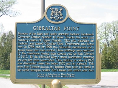
GIBRALTAR POINT
Because of its large and easily defended harbour Lieutenant-
Governor Simcoe decided to make Toronto the naval and
military centre of Upper Canada. This site, guarding the
harbour, was named Gibraltar Point. Fortification was begun
here in 1794 and by 1800 two defensible storehouses and a
guard house had been erected. These buildings were destroyed
by the Americans during the second raid on York (Toronto)
in 1813. By the following May a small blockhouse mounting
one gun had been constructed. This building, in ruins by 1823,
was dismantled some time before 1833 and not replaced. This
area later became known as Hanlans Point after the family of
the world-champion sculler “Ned” Hanlon who settled near here.
Erected by the Archaeological and Historic Sites Board,
Department of Public Records and Archives of Ontario
Location
Pointe de Gibraltar
Hanlans Point, îles de Toronto
Toronto
Ontario
Pointe de Gibraltar
Hanlans Point, îles de Toronto
Toronto
Ontario
Coordonnées GPS
Lat. 43.6272575
Long. -79.3897392
Lat. 43.6272575
Long. -79.3897392